

What is the Odd Fellows tract? Should RDU and Wake Stone be permitted to destroy an "extremely pretty and picturesque location"?
The Odd Fellows tract is not some random tract of land in the middle of nowhere; it is a small piece of Western NC mountains located in the RTP.

This write up is intended as a reference for those reading about the RDU-Wake Stone-Umstead State Park Saga but are not familiar the Odd Fellows tract and its high significance to Umstead State Park.

The Odd Fellows tract is not some random tract of land in the middle of nowhere with no historical or social significance. It is the exact opposite. The Odd Fellows tract, while small (70 acres), is a beautiful, unique tract in a very critical location adjacent to a highly used State Park (which started as a nation park) and a major creek (Crabtree Creek). Odd Fellows has several tributaries, steep ravines, and a historical pond and is associated with 90+ years of publicly funded planning for inclusion into the Park. To this day, Odd Fellows is deeded to the public; it is NOT private land. Given this history, should this public land be handed over to a private company in order to create an open mine rock quarry pit (which would result in the land being deforested, denuded of soil, and a 400-foot hole created)?
There are a few smaller tracts of land located in between Old Reedy Creek (ORC) Road and the main 70-acre Odd Fellows tract. In the eyes of the public today, these are also a part of the Odd Fellows. But for the purposes of this write-up, when I say “Odd Fellows”, I am referring to the primary 70-acre tract that, at one point, was owned by The International Order of Odd Fellows.
HISTORY OF UMSTEAD STATE PARK
Umstead State Park started in the mid-1930’s under the National Park Service (NPS) as the Crabtree Creek National Recreation Demonstration Area (RDA). Included in the very first land acquisition list that I found while researching the Park’s history at several National Archive locations and in all of the maps that I found, is a 70-acre tract of land labeled as Tract 21 that is now referred to locally as Odd Fellows.

The original appraisal for Tract 21 (Odd Fellows) indicated that “the extremely pretty and picturesque location gives an added value.” Tract 21 (Odd Fellows) is located directly adjacent to Crabtree Creek, a significant creek in the Wake County area back then and to this day. This area of Crabtree Creek has some nice viewpoints and some interesting boulders in the creek. Tract 21 (Odd Fellows) is unique to this area as it has steep terrain; it is like a little slice of the Western NC mountains located in Central NC.

According to the earliest Options list that I found, Tract 21 (Odd Fellows) was, in the 1930’s, the most expensive tract of land per acre that the federal government wanted to include in the Park!!

Not surprisingly, the owner did not want to sell it! However, this did not deter the National Park Service and so Tract 21 remained on the land acquisition list. Unfortunately, in the 1940’s WWII halted the federal government’s ability to complete land acquisition for many parks, including the Crabtree Creek RDA. In 1943, as planned from the beginning, the federal government transferred the Crabtree Creek RDA to the State of North Carolina and the State was to continue land acquisition. In 1955, the Crabtree Creek RDA was renamed to The William B. Umstead State Park. Even after the transfer from the federal government to the State of NC, Tract 21 (Odd Fellows) remained as a desired tract for inclusion into Umstead State Park. The result being that since the 1930’s, CONTINUOUSLY, decade after decade and to this day, public plans made using public money have called for Odd Fellows to be a part of Umstead State Park.
Tract 21 (Odd Fellows) Ownership History
JPH Adam, who at one time was the Mayor of Cary, sold Tract 21 to the Kleins in 1915 shortly before his death in 1917. The Klein family held Tract 21 until 1952. Between 1952 and 1958, Tract 21 was owned by CF Parrish, then Cyrus Thompson, and then CO Weaver. In 1958, the International Order of Odd Fellows (IOOF) purchased Tract 21 and used it as a forested recreation area until 1976 when RDU took control of the land via threat of condemnation (even though the land was outside of the planned Airport boundary). The IOOF encouraged people to use the land for outdoor recreation, including swimming, camping, and hiking. Under the ownership of the IOOF, Foxcroft Lake was enhanced with swimming platforms, beaches, etc. Foxcroft Lake spans the border of Odd Fellows and Umstead State Park and is a local historic cultural feature. Within a year or so prior to the forced sale, the IOOF moved an old building from RDU managed property to their property. Since the forced sale in 1976, the Boy Scouts have continued to host large group camping events several times a year on Odd Fellows and RDU was aware that the public used Odd Fellows for hiking, uses consistent with the long-planned use of this Tract.
HOW MANAGEMENT CONTROL OF ODD FELLOWS FELL TO THE RALEIGH-DURHAM AIRPORT
Unfortunately, the State’s governmental structure from the 1920’s through the 1970’s, had one person overseeing a good number of contradictory departments. The NC Department of Conservation and Development (NC C&D) was led by one Chairman and this Chairman answered only to the Governor. NC C&D housed mining, parks, development, forestry. Given this oversight, the Chairman could orchestrate land uses to his preference; he could influence if land was to be used for a park or a mine or a development. As State Parks was under the NC C&D, the Chairman knew of land acquisition plans for Umstead State Park. He also knew of the 1950’s plans for the creation of Lake Crabtree and the 1960’s Research Triangle Regional Planning Commission calling for the area between Brier Creek and Crabtree Creek and a bit beyond to be used for conservation and recreation. While not under the direct purview of NC C&D, the Chairman was also familiar with the development plans for the RDU Airport. This is critical as RDU chose to locate itself directly to Umstead State Park and, in fact, RDU’s first land acquisition include planned Park land (where Big Lake was eventually built). In the 1960’s, the Chairman of NC C&D was a very prominent developer in the Wake County, NC area. This person would eventually be appointed to the Raleigh-Durham Airport Authority (RDUAA) and be the lead of the land acquisition and appraisal committee. At one point, the Chairman of NC C&D actually made plans for Umstead State Park to be turned into a commercial recreation area (with a golf course, shooting range, etc.).


The RDU Airport was established after the Park was established. RDU chose to locate itself directly adjacent to the Park and, in fact, the first land acquisition for RDU included planned Park land (where Big Lake was eventually built). Several runways were built in the 1940’s according to the initial Airport Layout Plan (ALP). This included today’s 5R-23L (the runway closest to Umstead Stat Park) and 14-32 (the general aviation runway). The 1940’s ALP also planned for the future runways (e.g., 5L-23R). By the early 1960’s, Runway 5-23 (today’s 5R-23L) was established as the primary runway and it was clear that another main runway was needed. Instead of following the original 1940’s plan for the new primary runway to be located to the west of the initial primary runway and away from Umstead State Park (i.e., instead of building the current 5R-23L), RDU spent millions of public dollars trying to grow into Umstead State Park instead of following the initial 1940’s plan to grow away from the Park. The 1960’s RDU planners proposed several NEW plans, all of which encroached into the existing and planned public park land.

Plan A put a runway directly adjacent to Umstead State Park and physically took land from Umstead State Park in addition to taking planned Park land. Plan A was nixed by the early 1970’s. RDU then pursued Plan B which called for a new main runway to be built parallel to and next to I-40 (e.g., 14R-23L) and for the current General Aviation runway to be expanded (e.g., 14L-23R). Plan B would have resulted in two main runways projecting traffic over Umstead State Park, over the Research Triangle Park (RTP), and over downtown Raleigh. Plan B was opposed by Airlines, Air Traffic Controllers, RTP business and planners, State agencies, and Umstead State Park supporters.
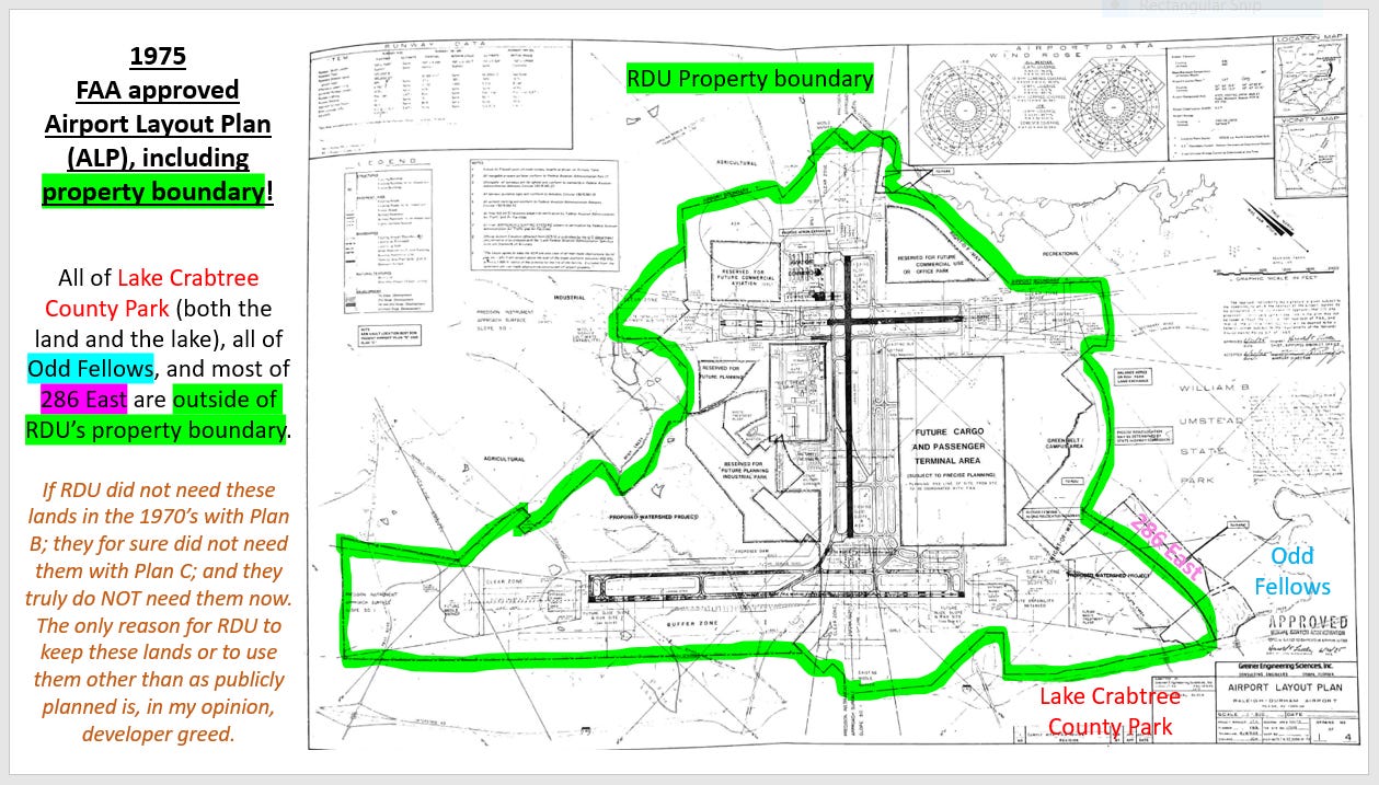
Even with this intense opposition, RDU submitted the Plan B Airport Layout Plan (ALP) to the FAA. In 1975, the FAA approved the Airport Layout Plan (ALP) that corresponded to Plan B. Plan B clearly showed Odd Fellows (and part of 286 East and all of Lake Crabtree Count Park) as totally outside of the Airport boundary. In fact, RDU had not yet taken control of Odd Fellows at this time. Also, Odd Fellows is located adjacent to the part of 286 East that was to be transferred to Umstead State Park. If Odd Fellows was not needed for RDU’s Plan B, then for sure, Odd Fellows was not and has never been need for any Airport use. Why would RDU take it?

The stretch of I-40 between Raleigh and Chapel Hill was built in the late 1960’s and early 1970’s and it was built just south of Umstead State Park, creating a natural border for the Park. During this same time frame, multiple publicly funded plans (e.g., State Parks, Research Triangle Regional Planning Commission, etc.), called for all land between Umstead State Park and I-40 to become part of the Park for both protection and for public use. Given the location of Tract 21, this means that all of these publicly funded plans called for Tract 21 (Odd Fellows) in its entirety to be incorporated into Umstead State Park!!
Per publicly available documents from the 1960’s and 1970’s, RDU staff were frustrated with the “fanatical savers of the Park” and intentionally set out to take all land between the Airport and the Park whether or not it was truly needed for Airport use. At one point, RDU staff claimed they needed to protect the Airport from encroachment by the Park when, in fact, it was the Airport encroaching into the Park and into planned park land. The problem was, the Airport had access to federal funds and could play a shell game with shifting money around to “acquire” land even if it was not needed while the State Park system had to go through the slow public process of acquiring land.
In the 1970’s, planning for the Crabtree Creek Sewer interceptor (a publicly funded project with EPA involvement) was underway. Per the Jan/1975 draft Environmental Impact Statement (EIS), this sewer line was to run north of I 40, through all of the planned Park land from Crabtree Creek to about Trenton Ave. This included land in the Odd Fellows area and in the current Triangle Quarry site area. In Apr/1975, the Assistant Secretary of NC Department of Natural and Economic Resources (DNER) wrote a letter to the EPA asking for the sewer line to be moved south of I-40 for the because “The land between I-40 and the present Park boundary is scheduled for acquisition by the State for inclusion into the State Park.” Per the Jun/1976 Final EIS for the Crabtree Creek Sewer interceptor, the EPA complied with the State’s request and moved the sewer line to accommodate the State’s planned purchase of Odd Fellows and the current Triangle Quarry site! Sadly, the State’s request to move the sewer line opened the door for Wake Stone and RDU to take advantage of the State Park’s slow land acquisition process. State Parks did not have ready access to money and had to go through a public process to utilize public money. But, RDU and Wake Stone had ready access to money. RDU could play a shell game and shift federal money around and/or get federal loans for other projects so they could use Airport generated funds. Wake Stone had access to private money.
In Jul/1976, one month after the Crabtree Creek Sewer interceptor Final EIS, RDU Airport took management control of Odd Fellows under threat of condemnation. Why would the Airport threaten to condemn land that is located well outside of the FAA approved Airport boundary?

Public records indicate that RDU’s Plan B was formally nixed by 1977. RDU then focused expansion efforts to the West (away from Umstead State Park) as per the initial 1940’s ALP. Unfortunately, RDU had taken management control of all planned Park land and unnecessarily kept the Airport District overlay on these planned park lands until the early 1980’s.
Since 1976, Odd Fellows has remained under RDU management and RDU has done absolutely nothing with it. Since 1976, State Parks has continued to plan for Odd Fellows to become part of Umstead State Park. Since 1976, the Boy Scouts continued to host camping trips on Odd Fellows and RDU acknowledged that the public was using the land as an extension of the Park for hiking and biking. This, to me, makes it seem like the RDU Airport manager through 2011, John Brantly, actually respected the numerous publicly funded plans that called for Odd Fellows (and 286 and LCCP) to be used for conservation and recreation – to be park land. It was like RDU was staying in their lane and trying to be a good neighbor to Umstead State Park. Also, don’t forget that since 1981, State Parks has been anticipating an end to Wake Stone’s Triangle Quarry by the year 2031. Wake Stone claims they want to be a good neighbor to Umstead State Park. Would a good neighbor stay beyond their welcome and take more of your space?

RDU SEEMED TO BE A GOOD NEIGHBOR AND THEN THERE WAS A CHANGE IN LEADERSHIP
In 2011, RDU management changed with the arrival of Mike Landguth as Chief Executive Officer (CEO) and Bill Sandifer as Chief Development Officer. At this point, things drastically changed. Under their leadership, the behind-the-scenes Vision 2040 planning process started shortly after their arrival. There was already a quarry friendly person on the RDUAA (Robert Teer Jr.). Additional developer/quarry friendly people finagled their way onto the RDUAA (e.g., Dickie Thomson, John Kane, Lawrence R. Zucchino, Sepi Saidi, etc.). Behind closed doors, these people planned land uses that were totally contradictory to the existing and long- standing land uses.
RDU’s so-called “public” process for the development of the Vision 2040 Master Plan started in 2015 with poster presentations. RDU calls these presentations “workshops,” implying that there was two-way dialogue to discuss plans. But there was no two- way dialogue; the poster presentations were just RDU telling people what their plans were, one-way communication. During these poster presentations, some RDUAA members and RDU staff told the public that RDU had no plans to do anything with Odd Fellows. However, in Jun/2016, at the 7th poster presentation, RDU announced their one and only land use plan made with zero public input and this land use plan designated Odd Fellows as a rock quarry. This designation blind-sided the public given RDU had assured the public that there were no plans to use Odd Fellows. In Oct/2016, RDUAA approved their one and only land use plan as it had been presented. Given no changes were made subsequent to public comments, it is clear that RDU did not consider public input. RDU’s intentional demise of all planned park land between Aviation Parkway and Harrison Ave. was officially underway. During this time, it was also clear that RDU was using the FAA as a crutch for validating their reasoning for ignoring the 90+ years of documented publicly funded planning for this land. RDU claims that they have to develop the land because the FAA says they have to make money! RDU could release the land if they chose to do so …
WHY DOES RDU WANT TO PUT A ROCK QUARRY ON ODD FELLOW?
RDU claims they need the rock quarry for the income to support other improvements at the Airport. But the quarry income represents only about 0.5% of the money they actually need. This is a small amount of money when one considers that Mike Landguth, RDU CEO, makes about $550,000 per year and Bill Sandifer makes a similar amount and that RDU is planning to spend several million to fully renovate the restrooms (that really are not that bad). In 2019, RDU leased the land to Wake Stone Corporation. Of note, several members of the RDUAA at the time of the Odd Fellows lease were friends of the family that owns Wake Stone.
WERE THERE ANY ALTERNATIVES TO THIS LEASE – YES!!!
In Jul/2017 The Conservation Fund offered to buy Odd Fellows for $6.4 million so it could be incorporated into Umstead State Park. The offer was solid and it was a win-win for the community (given all of the publicly funded plans calling for Odd Fellows to be a part of Umstead State Park) and the Airport (as they would have immediate access to a large sum of money) while the quarry is a win for the Airport and a loss for the public (the wasting of public planning money and the loss of a critical forested resource).
As per the graph below, it would take RDU a minimum of about 15 years from the start of the Odd Fellows lease to receive from Wake Stone the same funds as offered by The Conservation Fund. Also, RDU has never accounted for what the maintenance cost of the land will be once Wake Stone has completed their operations. The land is deeded to the public, so ultimately, the public will be responsible. (Of interest, in Jan/2020, NC State Parks offers to purchase the 286 East tract from RDU. RDU refused that too. Remember RDU’s encroachment claims? Who is encroaching on who? As I see it, RDU’s 1960’s goal of encroaching into the Park is closer to getting realized.)

So, the fight to preserve our long-planned (via public money) park land continues. More information can be found in my other write-ups. Hopefully this piece gave you a little bit better understanding of the critical nature of Odd Fellows.
While some, like Wake Stone Corporation (who was recently bought out by Vulcan Materials), describe the Odd Fellows tract as not useful because of its topography, the majority of the public will say, to this day, that the Odd Fellows tract is highly valued because of its topography (which is what the federal government recognized in their 1935 appraisal of this land). The question is, does a priceless and significant tract of land that is deeded to the public and that has continuously been on the Park acquisition list for 90+ years deserve to be given to a private company and turned into a rock quarry pit? Does The Public have a say in this or do The Elites control the outcome?
Disclaimer: I am an independent researcher. The information presented above is what I have found through publicly available records and my opinions formed from these records. I seek the truth, so if you see any errors or have additional input, please let me know.
Great write up Natalie, I love Umstead State Park and always visit when I come back to NC